Implementing an MCL Algorithm to Localize a Robot
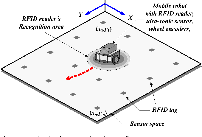
In this project, learners will have to implement an MCL algorithm to simulate the localization of a robot equipped with INS and RFID tags. The various steps in the algorithm have t…
Learn about the simultaneous localization and mapping of autonomous robots using Python.
Programming sets the foundation for the behavior of Autonomous Vehicles and robots. Python programming is one such language that lets users automate robots to respond to a wide range of different conditions instead of having to teach them how to respond to each one. Autonomous robots are programmed to independently navigate their environment by using localization and mapping techniques. As autonomous robots and vehicles are a growing trend, knowing how to program them is a vital skill sought after in the industry.
By taking this course, learners will
Who can enroll in this course?
This course comes under the autonomous domain, and can be taken by learners with an interest in statistics, calculus and programming experience in C++ and Python
When it comes to autonomous robots, the process of localization uses data from sensors to determine their behaviours and responses. Sensors in the system provide data inputs to the robot regarding the environment, following which it implements an algorithm to determine its upcoming behaviours. It is important to understand how vehicles and robots navigate their environment through localization.
This week will cover
As events that autonomous robots may encounter are not always predicted, the probability theory is considered to work through uncertainties in the environment. By applying algorithms in probability theory, all possible outcomes can be calculated. It is important to understand the basic concepts of probability theory, and the different functions and algorithms employed in determining possible outcomes.
This week will cover
Probabilistic modelling takes the effect of random events into consideration to predict the occurrence of possible future outcomes. In robotics, Bayesian filtering is used for determining the possibilities of multiple perceptions to let the robot understand its relative position and orientation. It is important to understand how probabilistic modelling and Bayesian filtering work in the context of robotics.
This week will cover
The Kalman filter works to reduce the overall error covariance and uncertainty by combining all the uncertainties in terms of the robot’s state and sensor measurements. It is essential in localization, trajectory tracking, identifying parameters, positioning, and the control of robots. It is important to understand how the Kalman filter works in the automation of robots.
This week will cover
The extended Kalman filter is applied for non-linear systems, while the Kalman filter is used for linear systems. By using the extended variant of the Kalman filter, limitations from using the Kalman filter alone can be overcome. The unscented Kalman filter is a non-linear Kalman filter. It is important to understand the different Kalman filters and when they are used.
This week will cover
Particle filter localization, also called Monte Carlo Localization, is an algorithm implemented for localization. This algorithm predicts the position of the robot as it works its way through the environment by using a series of samples/particles. It is important to understand the implications of particle filter localization in the automation of robots.
This week will cover
Multi-sensor fusion is the means by which data from multiple sensors or sources are integrated to reduce the uncertainty of information from individual sources. This allows for accurate estimations of an autonomous robot’s location, position, and orientation. There are different methods and algorithms used in multi-sensor fusion, such as Kalman filtering and extended Kalman filtering. It is important to understand the algorithms used to combine data from multiple sensors.
This week will cover
Autonomous robots and vehicles develop maps of their surroundings through mapping. In this process, sensors are used to gather information about the surrounding environment, and create a map with it. Mapping is a concept central to the development of autonomous vehicles and robots, making it imperative for learners to understand the process of map generation.
This week will cover
SLAM (Simultaneous localization and mapping) is implemented for autonomous robots and vehicles to develop a map and localize the subject on that map. It programs the autonomous subject to navigate the environment on its own through localization and mapping. While localization uses input data from sensors to determine behaviours, mapping uses information from the sensors to develop a map for the subject to understand its positioning and orientation.
This week will cover
Graph SLAM takes information regarding the locations of the autonomous robot as initial and relative motion constraints to provide the future probabilities of its movement. It is important to understand how graph-based SLAM works in the development of a robot’s position and orientation.
This week will cover
FastSLAM is an algorithm that combines extended Kalman filters and particle filters to recursively predict full posterior distribution across the landmark locations and robot pose. It is important to understand how the FastSLAM algorithm works, and the mathematical derivations involved.
This week will cover
SLAM is used in mobile robotics to build and update the map of the environment that the robot has not explored by using sensors that get inputs from the surroundings. There are also other applications of SLAM. It is important to understand SLAM in the context of the Robotic Operating System (ROS).
This week will cover
Our projects are designed by experts in the industry to reflect industry standards. By working through our projects, Learners will gain a practical understanding of what they will take on at a larger-scale in the industry. In total, there are 2 Projects that are available in this program.
In this project, learners will have to implement an MCL algorithm to simulate the localization of a robot equipped with INS and RFID tags. The various steps in the algorithm have t…
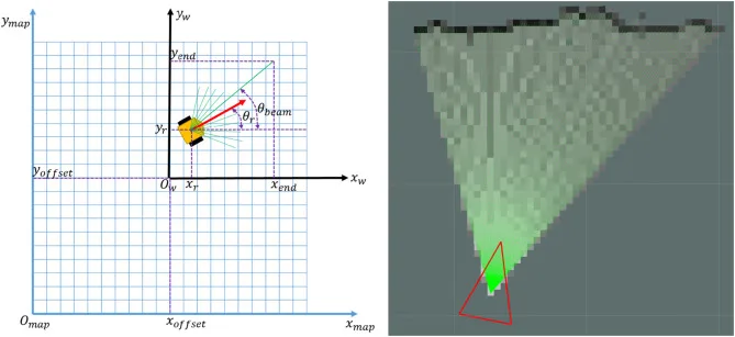
In this project, learners will have to implement an occupancy grid map algorithm using Turtlebot fitted with LiDAR and an accurate Odometry sensor. Learners will have a starter cod…
Become job ready with our comprehensive industry focused curriculum for freshers & early career professionals
Students and graduates of computer science and related engineering streams can take up Localization, Mapping, and SLAM using Python courses.
Yes, the SLAM localization course is 100% online.
The advanced localization and mapping course can be completed in 12 weeks.
According to Ambitionbox, the average annual salary of a robotics engineer is INR 3.5 lakhs. However, your pay package may vary with your experience and expertise.
Yes, you shall be given a course completion certificate after completing the Localization, Mapping, and SLAM using Python course. The top 5% of the scorers will receive a merit certificate alongside the course completion certificate.
Yes, you can clear your doubts during coursework from our technical support team through email and forum support.
Skill-Lync is among India's leading EdTech platforms dedicated to transforming engineering education. We equip young engineers with the latest skill sets and cutting-edge tools in new-age technologies.
The brainchild of two engineers from Chennai, Skill-Lync, is on a mission to bridge the skill gap between aspiring professionals and the industry's demands through job-oriented courses.
A counsellor will walk you through the syllabus, projects and fee options — and tell you honestly if another course suits you better.