Project 2
Q1:
Introduction
This report presents an establishment of the soil / rock profile and the ground water conditions,
general characteristics and variability of the ground. This profile is supplemented by In-situ and
laboratory testing in order to provide the design with sufficient information for the suitability of the
site and foundation, for the proposed structures.
This report refer as R3/SH15-023, covering Two (02) boreholes, in which One (01) borehole drilled
down to a depth of 30.0m & the other borehole drilled down to a depth of 20.0 m, below existing
ground level (EGL). The borehole locations are provided by the contractor M/s. Six Construct for
the proposed WasteWater Treatment Plant Capacity Upgrade Works-Ajman, U.A.E. Each
borehole/CPT locations were excavated approximately around 3.0m prior to start boreholes for
checking the presence of underground utilities.
Scope of work:
- Collect information about the site and project drawing, proposed constructions, etc.
- Carry out the assigned site investigative works as follows:
- Drilling of Two (02) exploratory boreholes down to a depth of 20m & 30m below existing
ground level involving the following:
o Regular split-spoon sampling during Standard Penetration Tests (SPT) in soils.
o Undisturbed rock sampling by double core drilling in rock.
o Groundwater level measurement & sampling.
- Performing Two (02) nos. Trail Pits down to a depth of ~3.0m below existing ground level.
- Installation of Two (02) nos. Standpipe Piezometer up to 20.0m below existing ground level
in both the boreholes (BH-01 & BH-02).
- Performing Twelve (12) nos. of Cone Penetration Tests (CPT) up to maximum 15.0m or
refusal.
- Laboratory Testing & Factual Reporting.
Standards and codes of practice:
The following international standards are referenced for field and laboratory testing:
BS 1377 Part 9 : 1990
AMD 8264 – 95 : Method of tests for soils for Civil Engineering Purposes.
BS 5930 : 1999 : Code of practice for site Investigations.
Site location:
The site is located in the Emirates of Ajman; United Arab Emirates about 4 kms from the Sheikh
Mohammad Bin Zayed Road (E311) and just 8 kms from the Arabian Gulf.
The as-built borehole coordinates and levels were provided by the contractor M/s. Six Construct
Company. The proposed site had been graded to +21.0m AMD, then local excavation to 3m was
executed at the location of the exploratory holes in order to check for services. The excavated
material was used to backfill all trail pit prior to start the boreholes. All the test locations and levels
were set out at the site by surveyor appointed by M/s. Six Construct. Before proceeding with the soil
investigation, the contractor leveled the site to ease the soil investigation work.
Field Works:
The assigned geotechnical investigation works mainly involve the following site activities / testing:
- Drilling of boreholes of 30.0 m depth - 01 Nos.
- Drilling of boreholes of 20.0 m depth - 01 Nos.
- Cone Penetration Test (CPT) - 12 Nos.
- Trail Pits (up to 3.0m depth) - 02 Nos.
- Standpipe piezometer installation - 02 Nos.
The investigative boreholes (02 Nos.) were drilled down to the depths 20m & 30m, below existing
ground level.
The disturbed split spoon samples were obtained through Standard Penetration Tests (SPT)
performed at 0.5 m intervals for the initial 3.0 m depth (from EGL) and at 1.0 m interval there after
down to the rock head level to assess the relative densities of the superficial materials.
The SPT consists of driving a standard 50 mm diameter (outer) thin wall sampler into soil from the
top of the test section, using repeated blows of a 63.5kg hammer falling through 760mm. The SPT
‘N’ value is the number of blows necessary to achieve the penetration of the split-barrel sampler to a
length of 300 mm (after its penetration under gravity and below the seating drive). Disturbed, split
spoon samples obtained from the boreholes were placed in air tight plastic bags before being
transported to laboratory for testing.
Spt test:
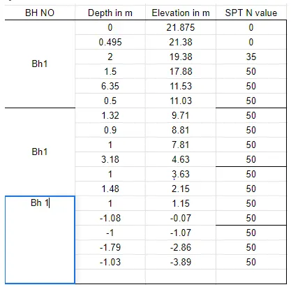
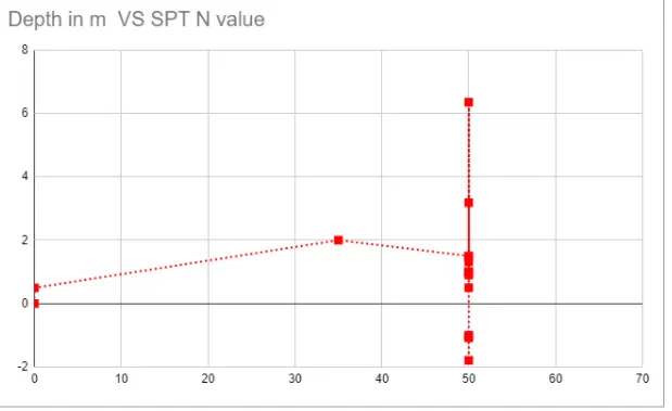
Characteristic line:
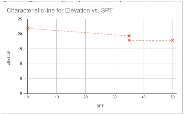
Similarly Depth vs Spt and characteristic line should be found for BH2
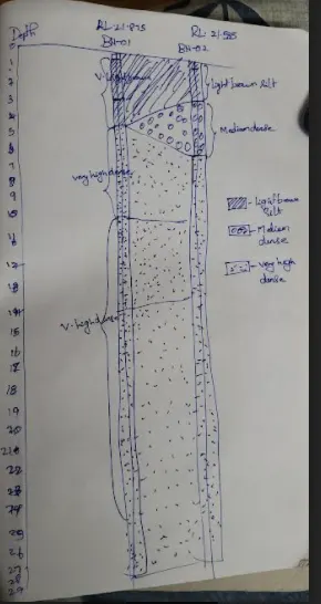
Soil profile:
Sub grade modulus:
K = Foundation pressure/settlement
Foundation pressure = 200 KPa = 200 kN/m^2
Settlement = 40mm = 0.04m
Set
K = ( 200/0.04) = 5000 kN/m^3