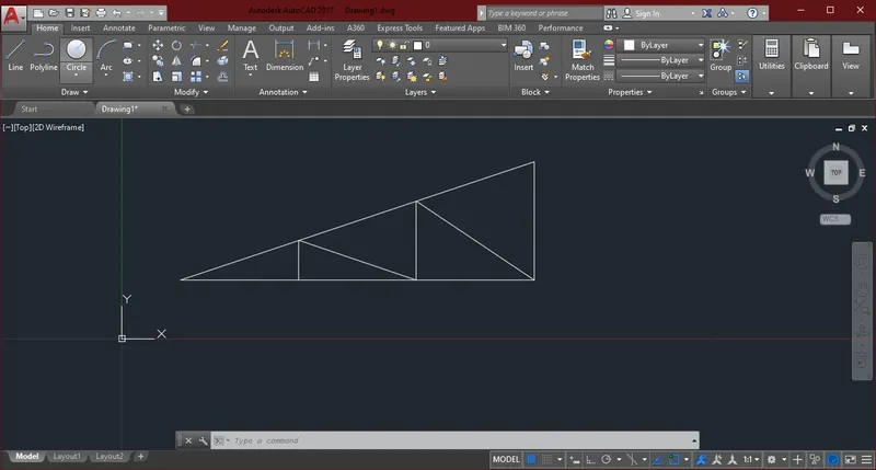
Creation of geometries by Coordinate system methods using AutoCad
Q1. Create the geometries from P1 to P2 using all the coordinates system methods. You need to use the Line tool to create the geometries.
AIM: Create the geometries from P1 using all the coordinates system methods.
INTRODUCTION: Co-ordinate system
- Absolute co-ordinate system : where you mention any point with respect to the origin (0,0)
- Relative co-ordinate system: Relative to certain point where you can refer another point with respect to last point.
- Relative rectangular co-ordinate: The relative coordinate with symbol "@" tell us Autocad it is a relative coordinate. Points entered by typing @x,y & it consists of 4 Quadrants.
- Relative polar co-ordinate: In mathematics, the polar coordinate system is a two dimensional coordinate system in which each point is determined by a distance from a reference point & an angle from a reference direction.
PROCEDURE:
A. Absolute coordinate system:
Line Command & Dynamic input OFF
- 2,1
- 8,1
- 8,2
- 3,2
- 3,6
- 8,6
- 8,7
- 2,7
- c enter
B. Relative Rectangular coordinate system:
Line Command
- 2,1
- Dynamic input ON
- 6,0
- 0,1
- -5,0
- 0,4
- 5,0
- 0,1
- -6,0
- 0,-6
C. Relative Polar coordinate system:
Line Command
- 2,1
- Dynamic input ON
- 6<0
- 1<90
- 5<180
- 4<90
- 5<0
- 1<90
- 6<180
- 6<270
RESULT:
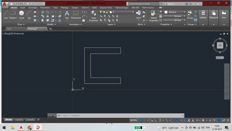
Q2. Create the geometries from P2 using all the coordinates system methods. You need to use the Line tool to create the geometries.
AIM: Create the geometries from P2 using all the coordinates system methods.
INTRODUCTION: Co-ordinate system
- Absolute co-ordinate system : where you mention any point with respect to the origin (0,0)
- Relative co-ordinate system: Relative to certain point where you can refer another point with respect to last point.
- Relative rectangular co-ordinate: The relative coordinate with symbol "@" tell us Autocad it is a relative coordinate. Points entered by typing @x,y & it consists of 4 Quadrants.
- Relative polar co-ordinate: In mathematics, the polar coordinate system is a two dimensional coordinate system in which each point is determined by a distance from a reference point & an angle from a reference direction.
PROCEDURE:
A. Absolute coordinate system:
Line Command & Dynamic input OFF
- 2,1
- 5,1
- 5,5
- 6,5
- 6,1
- 9,1
- 7,8
- 4,8
- c enter
B. Relative Rectangular coordinate system:
Line Command
- 2,1
- Dynamic input ON
- 3,0
- 0,4
- 1,0
- 0,-4
- 3,0
- -2,7
- -3,0
- -2,-7
C. Relative Polar coordinate system:
Line Command
- 2,1
- Dynamic input ON
- 3<0
- 4<90
- 1<0
- 4<270
- 3<0
- 7<106
- 3<180
- connect the line to the last point or End point
RESULT:
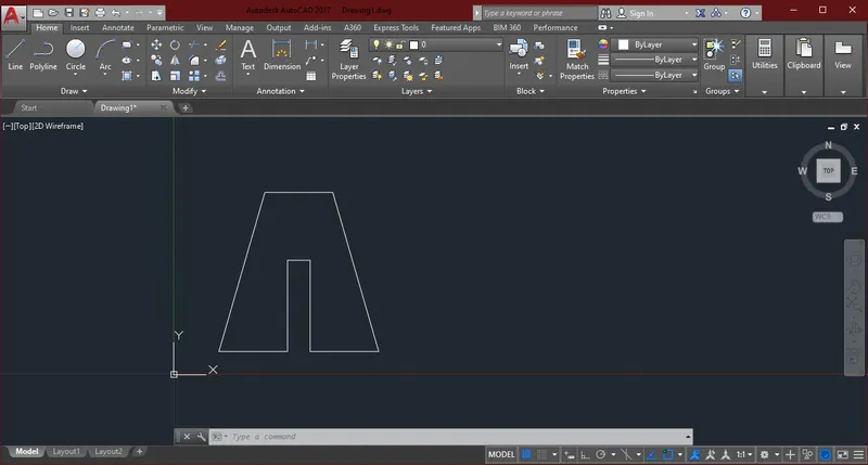
Q3. Create the geometries from using the coordinates system methods. You need to use the Line tool to create the geometries.
AIM: Create the geometries from using the coordinates system methods.
INTRODUCTION: Co-ordinate system
- Absolute co-ordinate system : where you mention any point with respect to the origin (0,0)
- Relative co-ordinate system: Relative to certain point where you can refer another point with respect to last point.
- Relative rectangular co-ordinate: The relative coordinate with symbol "@" tell us Autocad it is a relative coordinate. Points entered by typing @x,y & it consists of 4 Quadrants.
- Relative polar co-ordinate: In mathematics, the polar coordinate system is a two dimensional coordinate system in which each point is determined by a distance from a reference point & an angle from a reference direction.
PROCEDURE:
A. Absolute coordinate system:
Line Command & Dynamic input OFF
- 2,1
- 3,1
- 3,5
- 5,3
- 7,5
- 7,1
- 8,1
- 8,8
- 7,8
- 5 ,5
- 3,8
- 2,8
- 2,1
RESULT:
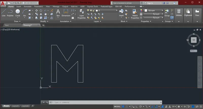
Q4. Create the geometries from using the coordinates system methods. You need to use the Line tool to create the geometries.
AIM: Create the geometries from using the coordinates system methods.
INTRODUCTION: Co-ordinate system
- Absolute co-ordinate system : where you mention any point with respect to the origin (0,0)
- Relative co-ordinate system: Relative to certain point where you can refer another point with respect to last point.
- Relative rectangular co-ordinate: The relative coordinate with symbol "@" tell us Autocad it is a relative coordinate. Points entered by typing @x,y & it consists of 4 Quadrants.
- Relative polar co-ordinate: In mathematics, the polar coordinate system is a two dimensional coordinate system in which each point is determined by a distance from a reference point & an angle from a reference direction.
PROCEDURE:
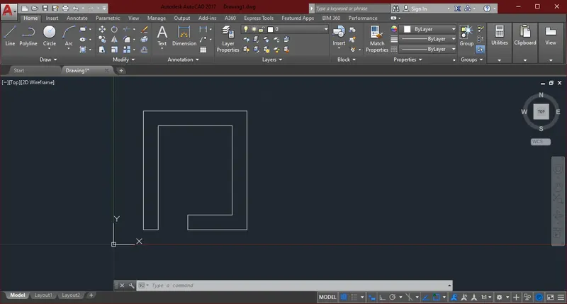
A. Relative Polar coordinate system:
Line Command & Dynamic input ON
- 2,1
- 1<0
- 7<90
- 5<0
- 6<270
- 3<180
- 1<270
- 4<0
- 8<90
- 7<180
- 8<270
RESULT:
Q5. Create the geometries from using the coordinates system methods. You need to use the Line tool to create the geometries.
AIM: Create the geometries from using the coordinates system methods.
INTRODUCTION: Co-ordinate system
- Absolute co-ordinate system : where you mention any point with respect to the origin (0,0)
- Relative co-ordinate system: Relative to certain point where you can refer another point with respect to last point.
- Relative rectangular co-ordinate: The relative coordinate with symbol "@" tell us Autocad it is a relative coordinate. Points entered by typing @x,y & it consists of 4 Quadrants.
- Relative polar co-ordinate: In mathematics, the polar coordinate system is a two dimensional coordinate system in which each point is determined by a distance from a reference point & an angle from a reference direction.
PROCEDURE:
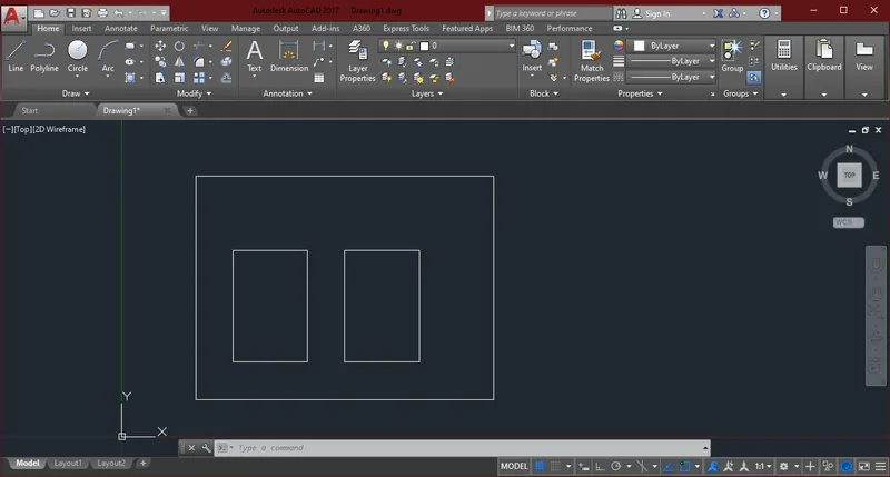
A. Absolute coordinate system:
Line Command & Dynamic input OFF
- 2,1
- 10,1
- 10,7
- 2,7
- 2,1
- Line command
- 3,2
- 5,2
- 5,5
- 3,5
- 3,2
- Line command
- 6,2
- 8,2
- 8,5
- 6,5
- 6,2
RESULT:
Q6. Create the geometries from using the coordinates system methods. You need to use the Line tool to create the geometries.
AIM: Create the geometries from using the coordinates system methods.
INTRODUCTION: Co-ordinate system
- Absolute co-ordinate system : where you mention any point with respect to the origin (0,0)
- Relative co-ordinate system: Relative to certain point where you can refer another point with respect to last point.
- Relative rectangular co-ordinate: The relative coordinate with symbol "@" tell us Autocad it is a relative coordinate. Points entered by typing @x,y & it consists of 4 Quadrants.
- Relative polar co-ordinate: In mathematics, the polar coordinate system is a two dimensional coordinate system in which each point is determined by a distance from a reference point & an angle from a reference direction.
PROCEDURE:
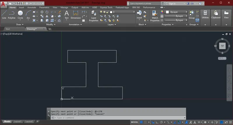
A. Relative Polar coordinate system:
Line Command & Dynamic input ON
- 0,1
- 10<0
- 2<90
- 4<180
- 4<90
- 3<0
- 2<90
- 8<180
- 2<270
- 3<0
- 4<270
- 4<180
- 2<270
RESULT:
Q7. Create the geometries from using the coordinates system methods. You need to use the Line tool to create the geometries.
AIM: Create the geometries from using the coordinates system methods.
INTRODUCTION: Co-ordinate system
- Absolute co-ordinate system : where you mention any point with respect to the origin (0,0)
- Relative co-ordinate system: Relative to certain point where you can refer another point with respect to last point.
- Relative rectangular co-ordinate: The relative coordinate with symbol "@" tell us Autocad it is a relative coordinate. Points entered by typing @x,y & it consists of 4 Quadrants.
- Relative polar co-ordinate: In mathematics, the polar coordinate system is a two dimensional coordinate system in which each point is determined by a distance from a reference point & an angle from a reference direction.
PROCEDURE:
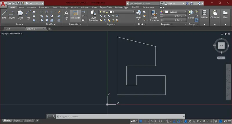
A. Absolute coordinate system:
Line Command & Dynamic input OFF
- 1,1
- 6,1
- 6,3
- 3,3
- 3,2
- 2,2
- 2,4
- 5,4
- 5,6
- 1,7
- 1,1
RESULT:
Q8. Create the geometries from using the coordinates system methods. You need to use the Line tool to create the geometries.
AIM: Create the geometries from using the coordinates system methods.
INTRODUCTION: Co-ordinate system
- Absolute co-ordinate system : where you mention any point with respect to the origin (0,0)
- Relative co-ordinate system: Relative to certain point where you can refer another point with respect to last point.
- Relative rectangular co-ordinate: The relative coordinate with symbol "@" tell us Autocad it is a relative coordinate. Points entered by typing @x,y & it consists of 4 Quadrants.
- Relative polar co-ordinate: In mathematics, the polar coordinate system is a two dimensional coordinate system in which each point is determined by a distance from a reference point & an angle from a reference direction.
PROCEDURE:
A. Absolute coordinate system:
Line Command & Dynamic input OFF
- 1,1
- 3,1
- 3,4
- 6,4
- 6,8
- 1,8
- 1,1
- Line Command
- 2,5
- 5,5
- 5,7
- 2,7
- 2,5
RESULT:
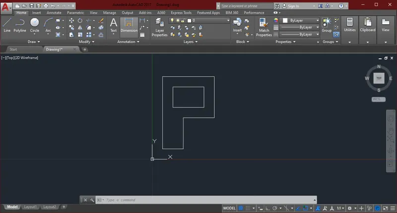
Q9.Draw the profile and the trusses using any coordinate system methods. The dimensions are there for references.
AIM: Draw the profile and the trusses using any coordinate system methods. The dimensions are there for references.
INTRODUCTION: Co-ordinate system
- Absolute co-ordinate system : where you mention any point with respect to the origin (0,0)
- Relative co-ordinate system: Relative to certain point where you can refer another point with respect to last point.
- Relative rectangular co-ordinate: The relative coordinate with symbol "@" tell us Autocad it is a relative coordinate. Points entered by typing @x,y & it consists of 4 Quadrants.
- Relative polar co-ordinate: In mathematics, the polar coordinate system is a two dimensional coordinate system in which each point is determined by a distance from a reference point & an angle from a reference direction.
PROCEDURE:
A. Absolute coordinate system:
Line Command & Dynamic input OFF
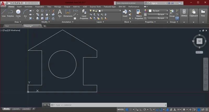
- 0,0
- 10,0
- 10,1
- 8,1
- 8,5
- 10,5
- 10,6
- 5,9
- 0,6
- 2,6
- 2,1
- 0,1
- 0,0
- Line command & Circle Diameter command
- 5,4
- Diameter 4
RESULT:
Q10.
AIM: Draw the profile and the trusses using any coordinate system methods. The dimensions are there for references.
INTRODUCTION: Co-ordinate system
- Absolute co-ordinate system : where you mention any point with respect to the origin (0,0)
- Relative co-ordinate system: Relative to certain point where you can refer another point with respect to last point.
- Relative rectangular co-ordinate: The relative coordinate with symbol "@" tell us Autocad it is a relative coordinate. Points entered by typing @x,y & it consists of 4 Quadrants.
- Relative polar co-ordinate: In mathematics, the polar coordinate system is a two dimensional coordinate system in which each point is determined by a distance from a reference point & an angle from a reference direction.
PROCEDURE:
A. Absolute coordinate system:
Line Command & Dynamic input OFF
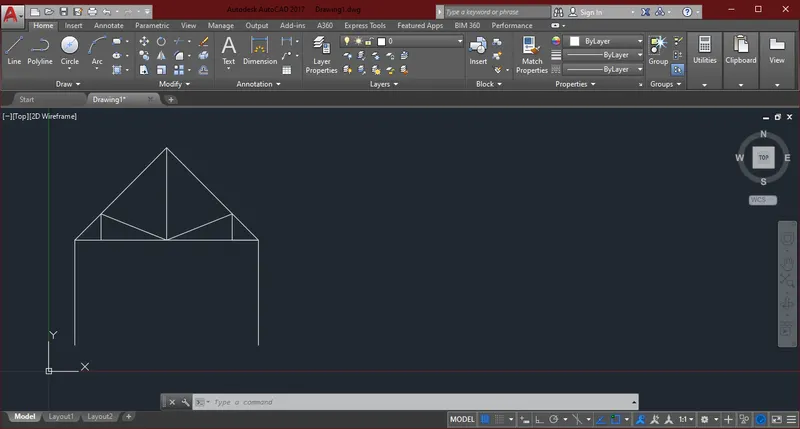
- 1,1
- 1,5
- 4.5,5
- 8,5
- 8,1
- LINE COMMAND
- 1,5
- 2,6
- 4.5,5
- 2,6
- 2,5
- LINE COMMAND
- 4.5,8.5
- 8,5
- 7,5
- 7,6
- 4.5,5
RESULT:
Q11.
AIM: Draw the profile and the trusses using any coordinate system methods. The dimensions are there for references.
INTRODUCTION: Co-ordinate system
- Absolute co-ordinate system : where you mention any point with respect to the origin (0,0)
- Relative co-ordinate system: Relative to certain point where you can refer another point with respect to last point.
- Relative rectangular co-ordinate: The relative coordinate with symbol "@" tell us Autocad it is a relative coordinate. Points entered by typing @x,y & it consists of 4 Quadrants.
- Relative polar co-ordinate: In mathematics, the polar coordinate system is a two dimensional coordinate system in which each point is determined by a distance from a reference point & an angle from a reference direction.
PROCEDURE:
A. Absolute coordinate system:
Line Command & Dynamic input OFF
- 1,1
- 7,3
- 7,1
- 1,1
- LINE COMMAND
- 3,1
- 3,1.667
- 5,1
- 5,2.333
- 7,1
RESULT: