Creation of geometries by Coordinate system methods using AutoCad
Question :- create the geometric from P1 and P2 using all the coordinates system methods . you need to use the line tool to
create the geometrics where required you need to use the circle point .
Note :- Use the imperial template and the decimal Units to draft the features . dimension are there for referance
ANS:-
AIM :- To create the geometric of the given drawings using all the coordiates system methods using line tools and circle .
Introduction :-
- coordinate systems :- there are four methods of coordintes system
1) Absolute coordintes system : Absolute coordinates based on the UCS origin (0,0) which is the intersection of the X and Y axes . Use absolute coordinates when you know the precise X and Y value of the point .
2) Relative rectangular coordinates system : relative coordinates are location defined by their distance from a refernce
point. to specify relative coordinates , preced the coordinates value with an @ sign . for example , entering @3,4
specifies point 3 units along X axis and 4 units along Y axis the last point specified .
3) polar coordinates system : To specify relative coordintes .preceds the coordinates value with an @ sign . for
example entering @1<45 specifies a point at a distance of 1 unit from the last point at an angle of 45 degree from
X axis
4) direct distance sysytem :- this is most common and easiest system used for drafting in Auto CAD . value are
provided through keyboard and direction is guided through the mouse .
Procedure :-
Drawing 1 : application > new > drawing > quick set up > decimal
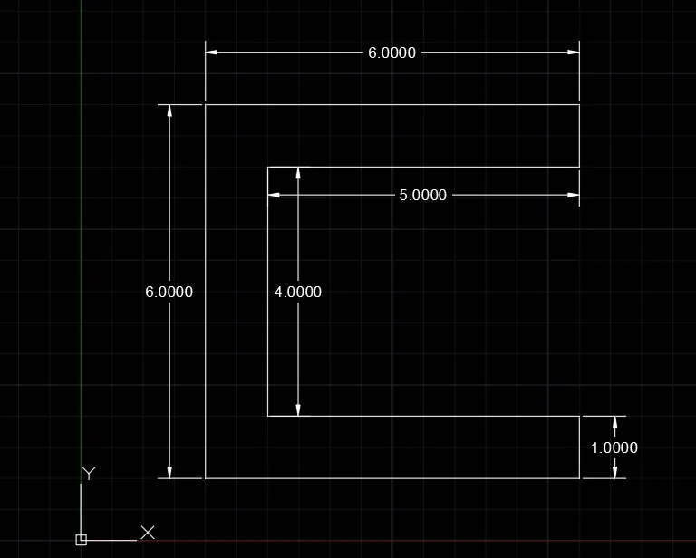
1) Absolute coordinates system :
command : limit
reset model space limit
specify lower left corner or [ ON / OFF ] <0.0>0.0
specify upper right corner [ 50,50 ]
command : L
LINE
specify first point : 2,1
specify next point : 8,1
specify next point : 8,2
specify next point : 3,2
specify next point : 3,6
specify next point : 8,6
specify next point : 8,7
specify next point : 2,7
specify next point : 2,1
specify next point : close command
2) Relative rectangular coordinates system :
command : line
specify first point : 2,1
specify next point : @6,0
specify next point : @0,1
specify next point : @-5,0
specify next point : @0,4
specify next point : @5,0
specify next point : @0,1
specify next point : @-6,0
specify next point : close command
3) polar coordinates system :
command LINE
specify first point : 2,1
specify next point : @6<0
specify next point : @1<90
specify next point : @5<180
specify next point : @4<90
specify next point: @5<0
specify next point : @1<90
specify next point : @6<180
specify next point : @6<270
4) direct distance coordinates system
command LINE
specify first point :2,1
specify next point at distnace : 8
specify next point : at distance 1 along + y axis
specify next point : at distnace 5 along -x axis
specify next point : at distance 4 along +y axis
specify next point : at distance 5 along +x axis
specify next point : at distance 1 along +y axis
specify next point : at distance 6 along -x axis
specify next point : to close command
Drawing 2 : application > new > drawing > quick set up > decimal
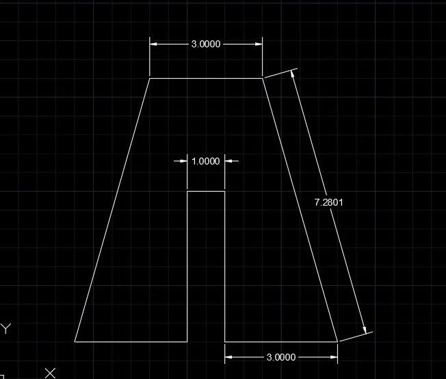
1) Absolute coordinates system :
command : LIMIT
reset model space limit :
specify lower left corner or [ ON/OFF ] ,0.0.;0,0
specify upper right corner <50,50>;50,50
command : L
LINE
specify first point : 2,1
specify next point : 5,1
specify next point : 5,5
specify next point : 6,5
specify next point : 6,1
specify next point : 9,1
specify next point : 7,8
specify next point : 4,8
specify next point : 2,1
2) Relative rectangular coordinates system :
command : line
spefify first point : 2,1
specify next point : @3,0
specify next point : @0,4
specify next point : @1,0
specify next point : @0,-4
specify next point : @3,0
specify next point : @-2,7
specify next point : @-3,0
specify next point : @-2,-7
3) polar coordinates system :
command : line
specify first point: 2,1
specify next point : @3,0
specify next point : @4,<90
specify next point : @1<0
specify next point : @4<270
specify next point : @3<0
specify next point : @7.28<105
specify next point : @3<180
specify next point : @c
4) direct distance system :
command : Line
specify first point : 2,1
specify next point : position the cursor and then enter the distance 3
specify next point : position the cursor and then enter the distnace 4
specify next point : position the cursor and then enter the distnace 1
specify next point : position the cursor and then enter the distance 4
specify next point : position the cursor and then enter the distnace 3
specify next point : position the cursor and then enter the distance 7.28
specify next point : positin the cursor and then enter the distnace 3
specify next point : close
Drawing 3 :
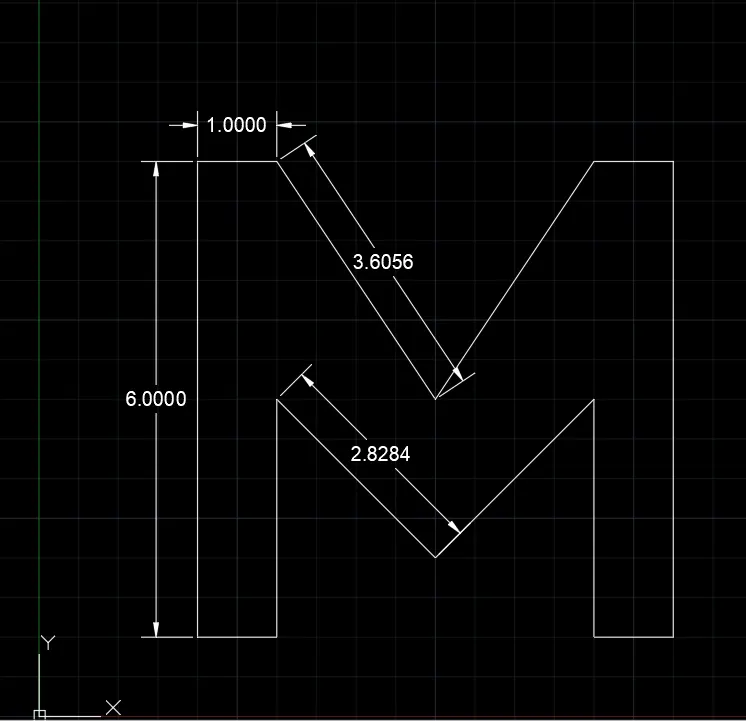
1) Absolute coordinates system :
command : LIMIT
Reset model space limit :
specify lower left corner or [ ON/OFF ] <0,0> : 0,0
specify upper right corner < 50,50> : 50,50
command : line
specify first point : 2,1
specify next point : 3,4
specify next point : 5,2
specify next point : 7,4
specify next point : 7,1
specify next point : 8,1
specify next point : 8,7
specify next point : 7,7
specify next point : 5,4
specify next point : 3,7
specify next point : 2,7
specify next point command : close
Drawing 4 :
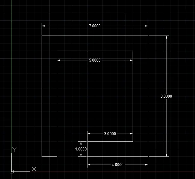
1) Polar coordinates system :
command : Line
specify first point : 2,1
specify next point : @1<0
speify next point : @7<90
specify next point : @5<0
specify next point : @6<270
specify next point : @3<180
specify next point : @1<270
specify next point : @4<0
specify next point : @8<90
specify next point : @7<180
specify next point : @8<270
Drawing 5 :
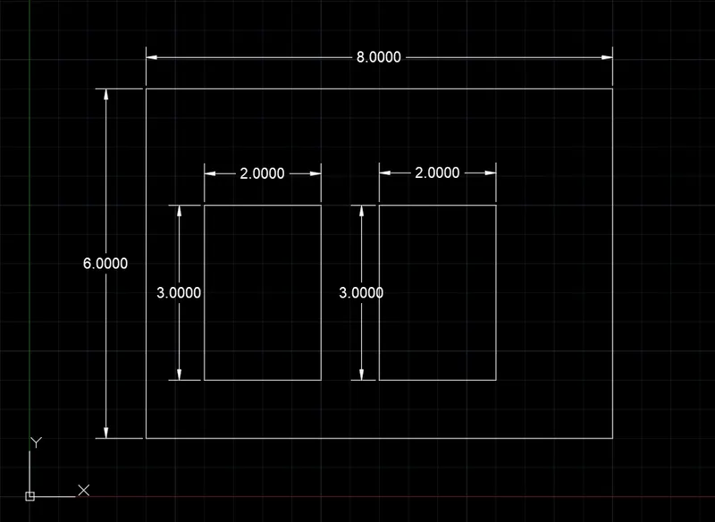
1) polar coordinates system :
command : line
specify first point : 2,1
specify next point : @8<0
specify next point : @6<90
specify next point : @8<180
specify next point : @6<270
specify next point : 3,2
specify next point : @2<0
specify next point : @3<90
specify next point : @2<180
specify next point : @3<270
specify next point : 6,2
specify next point : @2<0
specify next point : @3<90
specify next point : @2<180
specify next point : @3<270
Drawing 6 :
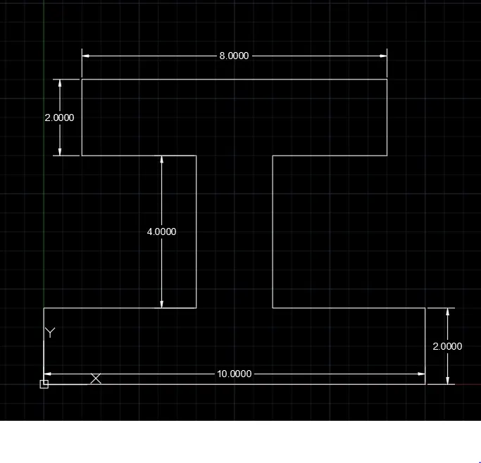
1) relative rectangular coordinates system :
command : Line
specify first point : 0,0
specify next poimt : @10,0
specify next point : @0,2
specify next point : @-4,0
specify next point : @0,4
specify next point : @3,0
specify next point : @0,2
specify next point : @-6,0
specify next point : @0,-2
specify next point : @3,0
specify next point : @0,-4
specify next point : @-4,0
specify next point : @-2,0
Drawing 7 :
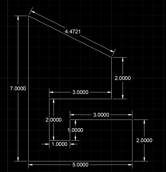
1) Relative rectangular coordinates system :
command : line
specify first point : 1,1
specify first point : @5,0
specify next point : @0,2
specify next point : @-3,0
specify next point : @0,-1
specify next point : @-1,0
specify next point : @0,2
specify next point : @3,0
specify next point : @0,2
specify next point : @-4,2
specify next point : @0,-7
Drawing 8 :
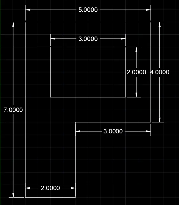
1) Polar coordiates system :
command : Line
specify first point : 1,1
specify next point : @2<0
specify next point : @3<90
specify next point : @3<0
specify next point : @4<90
specify next point : @5<180
specify next point : @7<270
specify next point : 2,5
specify next point : @3<0
specify next point : @2<90
specify next point : @3<180
specify next point : @2<270
RESULT :- uses of the all the coordinates system are diffrent types of purpose to draw the line tool .above all drawing draw
using four coordinates system .
Question : - Draw the profile and trusses using any coordinates system methods . the dimension are there are referance
ANS : -
AIM :- to create geometric of the given profile using relative coordinates system method & truss using absolute coordinates
system .
INTRODUCTION :-
Absolute coordinates uses the cartesian system to specify a position in the X ,Y , Z axes to locate a point
from the origin ( 0,0 ) point . to locate a point using the Absolute coordinates system , type the X-value
Y- value , and if needed , the Z-value separated by commas .
_ Relative polar coordinates system is used when we need to draw a new point of specified distance away
from the current point at a specified angle from the origin . using polar coordinates , point entered by
typing @distance
PROCEDURE :-
DRAFT 1 :
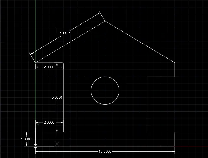
. To draft profile-wood using relative polar coordinates system :
command : line tool
speficy first point : 0,0
speficy next point : @10<0
specify next point : @1<90
specify next point : @2<180
specify next point : @4<90
specify next point : @2<0
specify next point : @1<90
specify next point : @5.831<149.036
specify next point : @5.831<210.964
specify next point : @2<0
specify next point : @5<270
specify next point : @2<180
specify next point : command close
speficy next point : command circle
specify centre point for circle : 5,4
specify radius of circle [diameter ] : 2
DRAFT 2 :
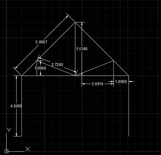
. To draft Queen Post Truss using absolute coordinates system
command : Line
specify first point : 1,1
specify next point : 1,5
specify next point : 2,5
specify next point : 2,6
specify next point : 4.536,5
specify next point : 4.536 , 8.536
specify next point : 1,5
press ENTER
Line specify first point : 2,5
speficy next point : 7.071,5
specify next point : 7.071,6
specify next point : 4.536,5
Press ENTER
Line speficy first point : 4.536 ,8.536
specify next point : 8.071,5
specify next point : 8.071,1
press ENTER
DRAFT 3 :
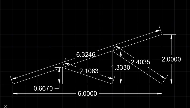
. To Draft Mono pitch using absolute coordinates system
command : Line
specify first point : 1,1
specify next point : 3,1
specify next Point : 3,1.667
specify next point : 5,1
speficy next point : 5,2.333
speficy next point : 7,1
specify next point : 7,3
specify next point : command close
line specify first point : 3,1
specify next point : 7,1
press ENTER .
RESULT :- Using line tool and circle above all draft are done with coordinates system .