Modified on
A Step-Wise Guide to Downloading Toposheets from the Survey of India Website

Skill-Lync
A topographic map, or toposheet, depicts a three-dimensional terrain area in two dimensions. Since topographic maps display the landscape's horizontal and vertical location, they set themselves apart from other types of maps. It uses a combination of colour, symbols, labels, contour lines, and other graphical elements for visual representation. Topographic maps show the shapes, locations, and various anthropogenic and natural elements. Survey of India has devised a map numbering system to make it easier to identify a specific area map.
Types of Toposheets
Scale-based classification of toposheets:
Large-scale Map: With a scale of 1 in 1000 or less
Medium-scale Map: These maps have a scale from 1 in 1000 to 1 in 10,000
Small-scale Map: Maps with a size of 1 in 10,000 or more.
Uses of Toposheets
- First, surveyors can use toposheets as a valuable resource.
- Additionally, it is utilised by map producers, such as baseline, meridian, and civil engineers.
- As a result, it is employed by historians, emergency service organisations, and managers of the environment and cities.
- Toposheets are quite helpful for planning different undertakings.
- As they offer the necessary information in the most practical format, construction planning is possible.
- A building complex, an industrial facility, a railway, and an irrigation project can all be planned using toposheets.
- The toposheets can be used to plan bridges, tunnels, and dams.
- These are useful for guiding military actions during times of conflict as well.
- In order to create hydropower schemes, landscapes, architecture, environmental protection, and agriculture, one can employ them.
- Last but not least, it is used in mining and other earth-based activities as well as many other visual disciplines.
Here’s a step-wise instructional guide on downloading toposheets from the Survey of India website.
Objective:
To download Toposheet from the Survey of India website
Tools used:
Google Chrome
Procedure:
Step 1:
Search for SOI nakshe in google
_1666790718.png)
Step 2:
Click on the first result found. It will redirect you to the online map portal.
https://onlinemaps.surveyofindia.gov.in/
_1666790776.png)
Step 3:
Click on the sign-in tab
_1666790818.png)
If you already have login fill in to proceed or click register here.
_1666790860.png)
Step 4:
In the prerequisites options, select necessary and click proceed.
_1666790904.png)
Step 5:
First step is to set username, Mobile number, and captcha
_1666790942.png)
Second step you will receive an OTP to the provided mobile number for verification.
_1666790976.png)
The third step is verification of Email, where you will receive mail with a one-time usable password. After you enter the credentials to the portal, you will be provided with a screen to set a new password.
Step 6:
This would be the page you end up after successful signing in.

Step 7:
On the left of the screen list of products that can be accessed will be provided, Where you need to select the open series map.

Step 8:
After entering the open series map, which is provided for free, You can download by knowing the sheet number or can search using the icon. Search is based on state and district.

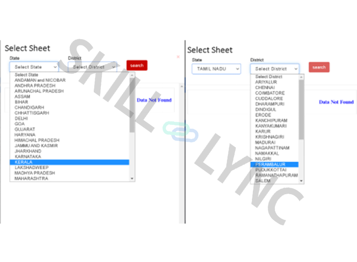
Step 9:
For example, when we select Tamilnadu you t of toposheeit t covering the region selected. lect the required Toposheet to proceed with downloading.

Step 10:
Oquired sheet, Sheet numitr appears. Click on download to proceed.

We need to enter the captcha for confirmation and accept the privacy polindia.

Author

Navin Baskar
Author
Skill-Lync
Subscribe to Our Free Newsletter

Continue Reading
Related Blogs
Through a graphical user interface, the user communicates with HEC-RAS (GUI). Making the software simple to use while still keeping a high level of user efficiency was the key goal while designing the interface.
04 Aug 2022
A stiffness modifier is a modification factor that is generally used in the properties of cross section such as moment of inertia, torsion etc., aiding in reducing the stiffness in concrete sections to model cracked behaviour of concrete. The stiffness modifier is applied only on concrete structures as it cracks on loading.
11 Aug 2022
Ellipse is a fundamental component of a conic section and shares many characteristics with a circle. An ellipse is oval in shape as opposed to a circle. An ellipse is a shape with an eccentricity less than one that symbolises a group of points whose distances from its two foci are added up to a fixed value. Everyday examples of the ellipse include the shape of an egg as well as the race track in a sports field.
16 Aug 2022
Revit enables professionals to access design and rendering functions in an exceedingly single program. this enables the designs to be created within the identical software that renders the ultimate images.
01 Sep 2022
Companies seek candidates who can differentiate themselves from the colossal pool of engineers. You could have a near-perfect CGPA and be a bookie, but the value you can provide to a company determines your worth.
03 Jul 2022
Author
Skill-Lync
Subscribe to Our Free Newsletter
Continue Reading
Related Blogs
Through a graphical user interface, the user communicates with HEC-RAS (GUI). Making the software simple to use while still keeping a high level of user efficiency was the key goal while designing the interface.
04 Aug 2022
A stiffness modifier is a modification factor that is generally used in the properties of cross section such as moment of inertia, torsion etc., aiding in reducing the stiffness in concrete sections to model cracked behaviour of concrete. The stiffness modifier is applied only on concrete structures as it cracks on loading.
11 Aug 2022
Ellipse is a fundamental component of a conic section and shares many characteristics with a circle. An ellipse is oval in shape as opposed to a circle. An ellipse is a shape with an eccentricity less than one that symbolises a group of points whose distances from its two foci are added up to a fixed value. Everyday examples of the ellipse include the shape of an egg as well as the race track in a sports field.
16 Aug 2022
Revit enables professionals to access design and rendering functions in an exceedingly single program. this enables the designs to be created within the identical software that renders the ultimate images.
01 Sep 2022
Companies seek candidates who can differentiate themselves from the colossal pool of engineers. You could have a near-perfect CGPA and be a bookie, but the value you can provide to a company determines your worth.
03 Jul 2022
Related Courses